
Sando has implemented, through an R&D&I project co-financed by CTA (Corporación Tecnológica de Andalucía) and in which the University of Jaén participates, an innovative technology for monitoring civil engineering infrastructures using radar data from satellites (SAR, Synthetic Aperture Radar). In this way, it has designed a new auscultation methodology capable of estimating ground displacements with high precision and which allows cost savings, increased reliability and frequency, and reduced occupational risks.
Juan Antonio Báez, director of the Sando Group’s R&D&I department, emphasizes that “thanks to this project, we can analyze ground deformations with great precision in record time, covering large areas and without the need for any prior knowledge of the area to monitor. We have developed a proprietary methodology using information from the Copernicus satellite.”
Carlos García, Technical Manager of Building and Civil Works at CTA, affirms that the Civilsar project developed by Sando “will represent an important qualitative and quantitative leap in predictive maintenance and risk prevention in infrastructures and civil works”. In his opinion, “the possibility of systematically using high-precision satellite data with wide spatial coverage makes it possible to greatly reduce costs and increase the reliability and frequency of site monitoring work. The latter have traditionally been supported by field inspection and topographic or geodetic works, which, despite being carried out in situ, do not reach the level of detail, scope and continuity of monitoring, almost daily, offered by the new technology”.
The RNM-282 Microgeodesia Jaén research group of the University of Jaén (UJA), an international benchmark in its sector, has participated in the project, thus achieving the transfer of knowledge from the scientific-university field to business activity.
New technology applications
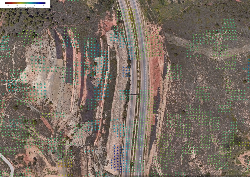
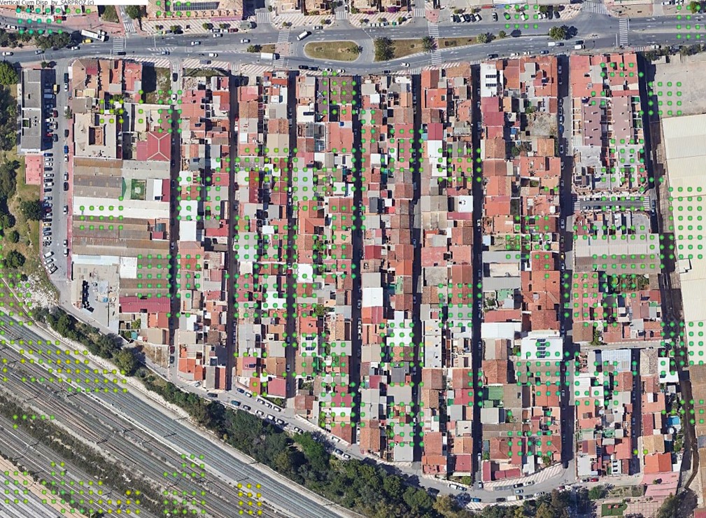
The new methodology developed in the Civilsar project will allow Sando to determine which areas, within a construction site or in the execution of a civil engineering project, should be subject to special auscultation or in which areas certain problems could occur, both during the execution of the work and afterwards. This technology improves occupational risk prevention by avoiding the direct exposure of people and makes it possible to anticipate risks thanks to predictive maintenance.
In addition, with a view to potential infrastructure and/or road network maintenance services, it will make it possible to know the areas or points where, due to ground displacements, there is a higher risk of landslides, breakage, etc., making it possible to establish the necessary surveillance.
This methodology is also applicable for the detailed study of the settlements and landslides associated with two key sectors, such as the environmental (linked to landfills and other infrastructures) and the miner (linked to the exploitation of materials that may have a direct impact on the land and its surroundings).
Sando has responded with a proposal based on this project to a preliminary market consultation launched by the Ministry of Transportation, Mobility and Urban Agenda for Innovative Public Procurement. The objective is to apply this technology to the maintenance of the country’s entire road network in order to do so in a predictive manner.
International commitment to SAR satellites
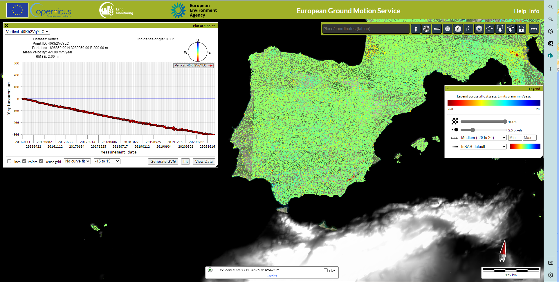
The project has been based on the InSAR methodology. (interferometry using synthetic aperture radar signals) that allow the determination of ground movements in the range of millimeters to a few centimeters of accuracy and has established the necessary parameters for differential analysis (DInSAR) using satellite data collected at different times, between which there has been some significant change in the terrain.
With the project, an innovative methodology has been implemented with respect to the traditional methodologies used in auscultation. Auscultation encompasses the set of techniques used for the geometric control of deformations, allowing a high spatial coverage, as well as the ability to perform studies both backwards in time and continuous current monitoring. All this is possible thanks to the possibility of using data already collected by the various satellites, as well as the international community’s commitment to the increasing use of SAR satellites, as demonstrated by the European Space Agency (ESA) with the Sentinel-1A/B satellites, whose data are provided free of charge.